
POSM NEWSLETTER
POSM City Sync & MapReader: New Integration and GIS Features
POSM is leveling up your sewer inspection workflow. With our new Cartegraph integration and an upgraded POSM MapReader, it's easier than ever to connect GIS and asset management data, eliminate manual entry, and keep inspections accurate and efficient—whether you're in the office or out in the field.
Update: Cartegraph is now part of OpenGov and is currently known as OpenGov Enterprise Asset Management. POSM City Sync continues to support this integration.

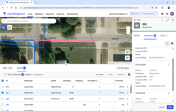
POSM inspections viewed within Cartegraph.
POSM City Sync Integration with OpenGov Enterprise Asset Management
We’re excited to announce that POSM City Sync connects directly with OpenGov Enterprise Asset Management (formerly Cartegraph), helping streamline the exchange of sewer inspection and asset management data.
With this new integration, your team can:
- Automatically sync POSM inspection data into Cartegraph using the latest API connection
- Access detailed reports, condition scores, and inspection videos right inside Cartegraph
- Enhance asset records with up-to-date inspection insights in one place
- Run data syncs on your schedule with automatic updates at intervals you choose
Whether you’re in the field or in the office, POSM City Sync keeps your data where you need it—without extra steps.

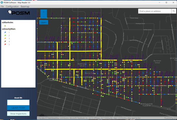
Inspected pipe segments highlighted in POSM MapReader.
Introducing the New and Improved POSM MapReader
The upgraded POSM MapReader is now available to all POSM Pro users. MapReader integrates GIS and inspection data for higher accuracy and faster inspection setup. It supports both cloud-based online maps and offline maps—so you can stay productive with or without internet access.
With the updated POSM MapReader, you can:
- Load inspection data directly from GIS with no manual typing
- Work online or offline in the field or office
- Pull real-time data from ArcGIS Online Web Maps
- Create offline replicas for limited connectivity areas
- Use customizable layers and fields to populate inspection details automatically
- Quickly identify uninspected lines with color-coded maps
- Search and zoom to addresses for faster navigation
- Select base layers to match your preferred map style or utility needs
This upgrade is all about saving time, reducing errors, and improving inspection efficiency.
POSM Software
posmsoftware.com | info@posmsoftware.com | 859-274-0041
